Preliminary modeling of tsunami potential in the Tanimbar Islands
Abstract
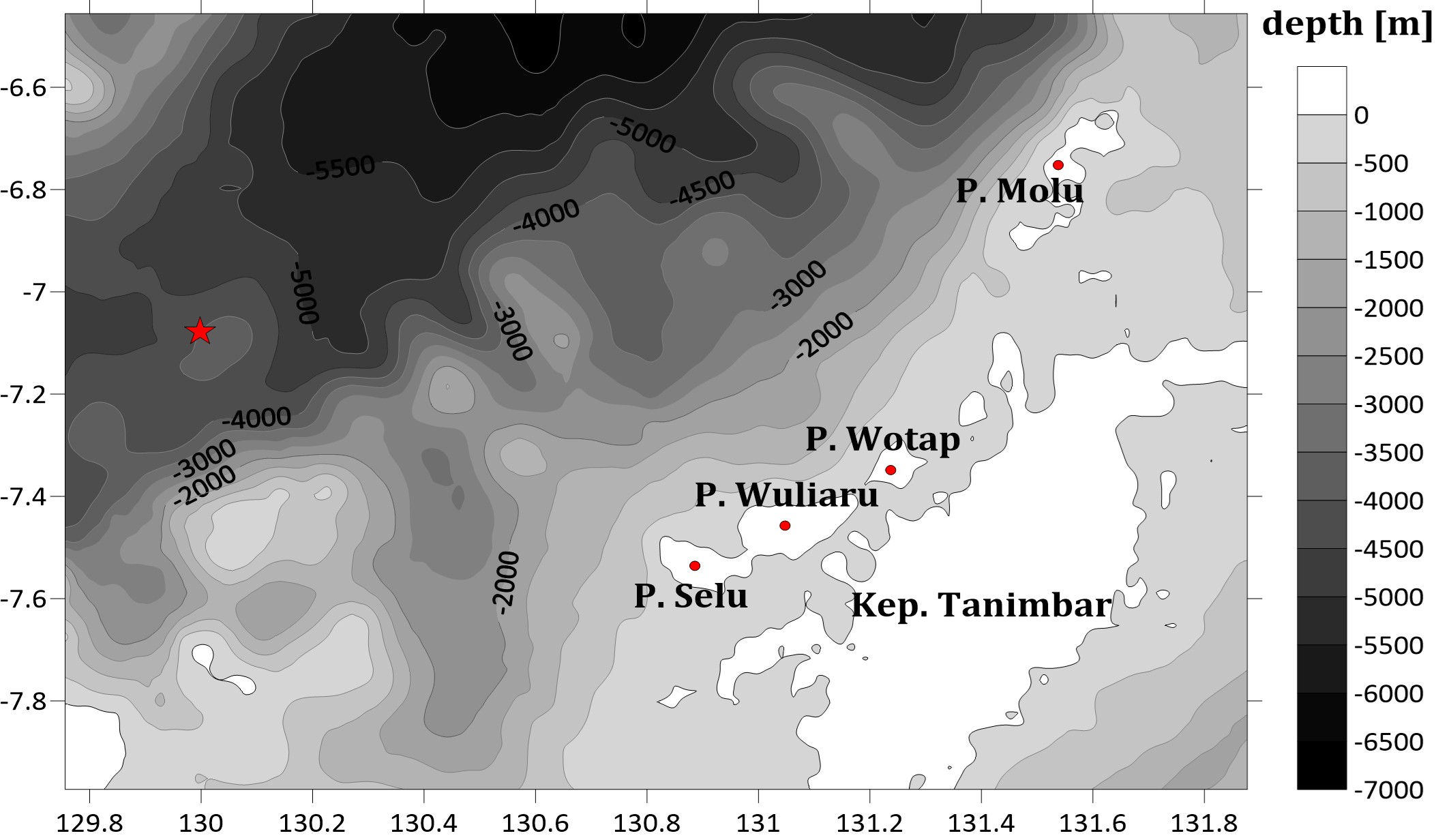
The Tanimbar Islands are an area of high tectonic activity and are part of the outer arc island chain formed by subduction in the Banda zone. The presence of the Sorong Fault and Tanimbar Fault around the Tanimbar Islands also affects the level of vulnerability to earthquakes and tsunami hazards. The purpose of this study was to predict the tsunami potential and affected area of the Tanimbar Islands. The method of analyzing the height data and predicting the affected area used COMCOT v1.7 software. Model simulations were performed on the domain layer by using linear equations. Earthquake and fault parameter data were obtained from the USGS website using historical earthquakes dated January 10, 2023. Bathymetry data were obtained from the GEBO website at a resolution of 15-arcsecond (464 m). The model simulation results show that the initial wave height value marked by the red contour is 0.22 m and the lowest low tide value marked by the blue contour is -0.4 m. Based on these results, the tsunami potential in the Tanimbar Islands is not dangerous, as the potentially affected areas in the study area are Selu Island, Woluaru Island, Wotap Island, and Molu Island, as well as the small islands in the western part. The simulation results demonstrate the importance of research related to tsunami hazards that may occur in the future so that appropriate mitigation can be planned for the existence of small islands around the Tanimbar Islands.
References
Alviani, P. (2021). Buku Pintar Penanggulangan Tsunami. Diva Press; Yogyakarta.
An, C., Ignacio, S., & Liu, P. L. F. (2014). Tsunami Source and It’s Validation of The 2014 Iquique, Chile Earthquake. Geophysical Research Letters, 41, 3988-3994. https://doi.org/10.1002/2014GL060567
Charlion, K. R. (2004). The petroleum of inversion anticlines in the Banda Arc. AAPG. Bulletin, 88, 565-586.
Fathianpour, A., Evans, B., Jelodar, M. B., & Wilkinson, S. (2023). Tsunami evacuation modelling via micro-simulation model. Progress in Disaster Science, 17, 100277. https://doi.org/10.1016/j.pdisas.2023.100277
Fuad, M. A. Z., Effendi, V. R., & Dewi, C. S. U. (2022). Application of sar remote sensing and geographic information systems (gis) in coastline change studies–a case study of coastline change due to the 2018 tsunami in tanjung lesung, banten. Asian Journal of Aquatic Sciences, 5(1), 87-98.
Ghazi, Z. M., Abbood, I. S., & Hejazi, F. (2022). Dynamic Evaluation of Jack-Up Platform Structure Under Wave Wind, Earthquake and Tsunami Loads. Journal of Ocean Engineering and Science, 7(1), 41-57. https://doi.org/10.1016/j.joes.2021.04.005
Hidayati, M. P., Purnama, A. Y., & Setyawan, D. N. (2022). E-Modul Fisika Berbasis Mitigasi Bencana Gempa Bumi. Deepublish; Yogyakarta.
Laksono, FX. A. T., Aditama, M. R., Setijadi, R., & Ramadhan, R. (2020). Run-Up height and flow depth simulation of 2006 South Jawa tsunami using COMCOT on Widrapayung Beach. Conf. Ser.: Mater. Sci. Eng, 1-11. https://doi.org/10.1088/1757-899X/982/1/012047
Lestari, D. A., Fitriasari, N. S., Ahmad, T. E., Rais, A., & Azhari, D. R. (2021). Spatial Analysis on Tsunami Predictions in Pandeglang Regency. Forum Geografi, 35(1), 103-115. https://doi.org/10.23917/forgeo.v35i1.12367
Mutmainah, H, Christiana, D. W., & Kusumah, G. (2016). Tsunami Mentawai 25 Oktober 2010 (simulasi COMCOT v1.7) dan Dampaknya Kini Terhadap Pantai Barat Mentawai. Jurnal Kelautan: Indonesia J. of Marine Science and Technology, 9(2), 175-187. https://doi.org/10.21107/jk.v9i2.1917
Mahmudah, S., & Supardi, Z. A. (2023). Analisis Parameter Kegempaan (Nilai-A Dan Nilai-B) Di Wilayah Busur Banda. Jurnal Riset Rumpun Matematika Dan Ilmu Pengetahuan Alam, 2(1), 254-262. https://doi.org/10.55606/jurrimipa.v2i1.1239
Rasyif, T. M., Shigeru, K., Syamsidik, & Okabe, T. (2019). Numerical Simulation of Morphological Changes due to the 2004 Tsunami Wave Around Banda Aceh, Indonesia. Geosciences, 9(125), 1-16. https://doi.org/10.3390/geosciences9030125
Ratuluhain, E. S., Nurjaya, W. I., & Natih, N. M. N. (2021). Analisis Potensi Tsunami di Lombok Utara. Jurnal Ilmu dan Teknologi Kelautan Tropis, 13(1): 113-126. J. Ilmu dan Teknologi Kelautan Tropis, 13(1), 13-126. https://doi.org/10.29244/jitkt.v13i1.29336
Ratuluhain, E. S., Noya, Y. A., Pradjoko, E., Rahman, & Hukubun, R. D. (2022). Rekonstruksi Tsunami Mentawai dengan Menggunakan COMCOT v1.7. NEKTON: Jurnal Perikanan dan Ilmu Kelautan, 2(2), 54-62. https://doi.org/10.47767/nekton.v2i2.403
Riyanda, R. A. (2016). Studi identifikasi cekungan Tanimbar untuk mengetahui pola sub-cekungan sedimen berpotensi hidrokarbon berdasarkan analisis gaya berat. (Undergraduate’s Thesis, UNILA). http://digilib.unila.ac.id/21388/3/SKRIPSI%20TANPA%20BAB%20PEMBAHASAN.pdf
Rudyawan, A., & Pamumpuni, A. (2023, March 28). Bertetangga Dengan Gunung Lumpur Bawah Laut. REKACIPTA ITB. https://pengabdian.lppm.itb.ac.id/information/bertetangga_dengan_gunung_lumpur_bawah_laut
Pradjoko, E., Kusuma, T., Setyandito, O., Suroso, A., & Harianto, B. (2014). The Tsunami Run-Up Assement of 1977 Sumba Earthquake in Kuta Center of Lombok, Indonesia. Prosedia Earth and Planetary Science, 14, 9-16. https://doi.org/10.1016/j.proeps.2015.07.079
Qonita, Z., Karima, S., Rusdiansyah, A., & Riyandari, R. (2024). Numerical modelling of The 1998 Papua New Guinea tsunami using COMCOT. Barekeng : Journals of Matematics and Its Applications, 18(1), 0349-0360. https://doi.org/10.30598/barekengvol18iss1pp0349-0362
Wang, X. (2009). User manual for COMCOT version 1.7 (First Draft). http://ceeserver.cee.conell.edu.//phllgroup/comcot_down.htm
Wanger, T. C., Ainun, N., Brook, B. W., Friess, D. A., Oh, R. R. Y., Rusdin, A., Smithers, S., & Tjoa, A. (2020). Ecosystem-Based Tsunami Mitigation for Tropical Biodiversity Hotspots. Trends in Ecology & Evolution, 35(2), 96-100. https://doi.org/10.1016/j.tree.2019.10.008
Widada, S. (2016). Analisis Dimensi Fraktal Kejadian Gempa di Laut Banda Indonesia. Jurnal Kelautan Tropis, 19(2), 108-114. https://doi.org/10.14710/jkt.v19i2.837
Widodo, A., Aditama, F. Y., Rochman, J. P. G. N., Karikasari, D., Putra, N. M., & Pribadi, S. (2024). Preliminary study of tsunami simulations on megathrust earthquake scenarios in Pacitan Regency, East Java. Conf. Ser.: Mater. Sci. Eng. https://doi.org/10.1088/1755-1315/1307/1/012004
Zhang, B., Ye, J., Zhou, H., Jeng, D. & Guo, Y. (2024). Enhancing Tsunami Modelling by using N-waves and The Measured Topography of Coral Reef: A study in the South China Sea. Coastal Engineering, 193, 104601. https://doi.org/10.1016/j.coastaleng.2024.104601
Copyright (c) 2025 Eva Susan Ratuluhain, Yunita Angnetjie Noya, Degen E. Kalay, Ronald Darlly Hukubun

This work is licensed under a Creative Commons Attribution-ShareAlike 4.0 International License.
Copyright on articles was retained by the respective author(s) without restrictions. The author grants the journal its first publication rights with the work simultaneously licensed under the Creative Commons Attribution-ShareAlike 4.0 International (CC BY-SA) license. This means anyone is free to copy, transform, or redistribute articles for any lawful purpose in any medium, provided they give appropriate attribution to the original author(s).